Sunday, October 16, 2011

A Heinous Loop

Heinous Loop is a combination road/mountain bike ride that runs through some of the prettiest spots in the Great Smoky National Park. It spans almost 60 miles and can punish an unready rider with a total ascent of nearly 5600'. It also rewards with fabulous scenic, fauna, and wildlife views. There are a number of ways to ride this, but all require a journey along Foothill Parkway a National Park road that ascends the northern boundary of GSNP and then dives down western border of the Chilhowee Lake section of the Tennessee River. The route then meanders placidly along the river before a seven mile stretch of vicious and writhing ascents and descents. This is the start of the section of US129 called "The Dragon" and is a siren call on weekends to motorcyclists and sports cars.

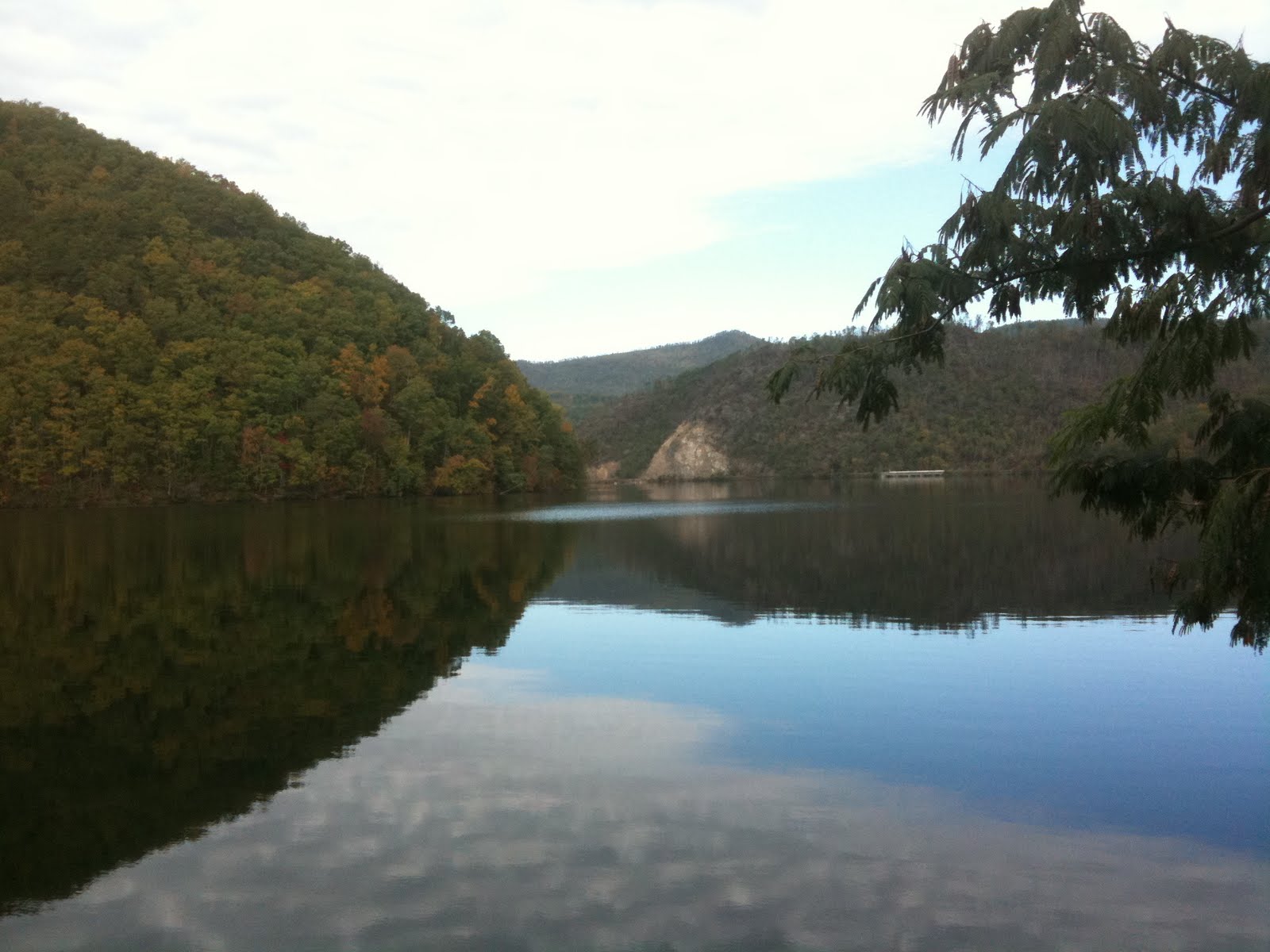
The route breaks free of the Dragon to join the dirt and gravel Parson's Branch Road. Climbing up 2000' in 5 miles to Panther Creek it intersects the trail head junction to Gregory Bald--a popular hiking trek to its 4949'peak. The road steeply descends back down those hard fought feet of elevation into the GSNP's most famous tourist destination: Cades Cove. Heinous Loop bisects a heavily traveled road that circumscribes Cades Cove and grants a rider 10 miles of relatively flat and epically beautiful scenery. Then it's time to climb one last time up and over Rich Mountain before closing the loop.


Naturally, in preparing for this planned 6 hour venture, I did some pre-ride conditioning at the New Belgium Brewery's "Clips of Faith" -- a beer and film festival held in the Knoxville World's Fair Park. Two "samples" in, it became more of a social night out with members of the local biking community as I don't recall any films though I'm sure they were being played. Let's just say that since all of the beer sales proceeds went to the Appalachian Mountain Biking Club, I could justifiably argue for life member status.

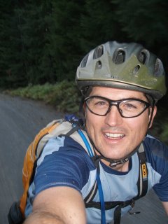
I launched for the ride start with a residual headache from "Ten Ten Ten" a fabulous New Belgium beer with an awesome taste seductively masking 10% alcohol content. My goal was a positive split but the first 6 miles up a 4% grade climb up Foothill Parkway challenged that immediately. I found a good groove though and kept the HR down in Zone 3 or better while still pacing at a decent rate despite carrying a full load of water (2l bag and a bottle), food, and support gear on my back. The backside was spent in a speedy tuck and the elevation and heart rate both descended quickly. Picking up the river, I cruised and lapped up the views of placid waters, changing fall colors, and the occasional slow or soon-to-be-forever snake along shoulder and road. I saw my first copperhead as he paused before the road; why there were so many snakes out I have no clue.

Entering the Dragon (not the Bruce Lee movie), the road ticked up and began a stretch reknown for its 318 turns in 11 miles. I would get 7 miles on it (202 corners?) before my turn off all while tucked tightly to the shoulder. The volume of motorcycles- cruisers and rocketships- picked up, interlaced with the occasional sportscar or out-of-place minivan. Soon almost every corner had a commercial photographer and prominent web banner, to sell things such as this:
I reached Parson's Branch --27 miles traveled-- in 2:10; ahead of schedule and just in time for lunch. A quick PBJ, an apple, and then up the trail towards Cade's Cove. Free of the near constant whine of performance 4 strokes, I settled into the rhythmic two stroke but sometimes wheezing exhaust of my Kona. After the busy Dragon, Parson's was church-like save the quiet rustling of falling leaves, cawing crows, and narcissistic tweets of cardinals. 10 miles and 10 cars was all I saw until I reached Cade's Cove.
Described as 16 miles of moving, linear parking, Cades' Cove lived up to its promise, as fall color tourist inched along it's roadway. I easily and enjoyable passed car after near-idling car as I scurried towards Rich Mountain and began one last long 4 mile climb up and out of the GNSP.

Mile 49-50 was the longest of the ride as the distance and elevation started to take it's toll and a positive split began to look like the bridge too far. In fact the top of that last hill looked too damn far. But, in the immortal words of Jean Paul Sartre, "I peddle, therefore, I must peddle." (maybe it was someone else besides that tiny, annoying voice in my still aching head)


Up and over and a long and fast final dirt stretch and then a whoop inducing smooth, switchback laced road into Townsend. The last few miles were a cool down along the Little River as the muscles finally began to register their objections to a nearly continuous 5 hours of climbing and spinning. Back at the car at 4:58 having missed my positive split, but positive that this was a Fabulous Loop and not a Heinous one after all.

Sunday, April 17, 2011

A River Runs Through It--and so do I

My last run before I hit the mid-century mark almost became a swim. Friday evening we had a torrential downpour and high winds and rain showers were forecast for Saturday. The winds arrived late and the showers gave way to sunny skies as I made my way down to Meigs Trail in the Smokies.

The trail head is at the famous Sinks approached in a drive up along the Little River--which it definitely wasn't this day. It was swollen and angry.This gave me a bit of angst because my 12 mile route was amongst many of the tributaries that fed this river.

The Meigs Creek Trail climbed quickly away from Little River but the roar of it followed me a long way. Cresting a ridge, the trail dropped just as quickly down to Meigs Creek which it follows for 2+ miles before the final ascent to Meigs Mountain.

"Follows along" is probably a misnomer. The trail meanders liberally through the creek. And creek itself was an inappropriate label this day, as well, given the prior night's deluge. Arriving at my first crossing, I stripped off my shoes and socks, removed the liners, found a sturdy stick and forded the swift water to the other side where I reversed the process after dumping water from my waterproof shoes (heretofore to be known as well-sealed vessels for storing water). Feet somewhat dry, I continued my run up the trail where 30 yards later--it crossed the creek again! I repeated the process with still fairly dry feet and socks and resumed my run. To reach another creek crossing 50 yards later.


Having learned my lesson, I plunged on through and continued this process for the next 17 crossings to come. Correct. Seventeen more.


Upper Meigs Falls was running wildly as I trudged and sloshed past to ford the swift creek feeding it just yards later.

Reaching Bukhorn Gap at the 3.3 mile mark and 45 minutes later (slow going with half the trail being a swim) I finally dropped the wet socks, contemplated dry ones, but decided to save those for the last descent just in case. A wise choice (I think) though still I earned a blister from running sock naked with wet feet.

The route from Upper Buckhork was largely 3+ miles of contour trail affording ample views of the ridge above me and Curry He and Curry She Mountains. At 3000 feet, the trees were just budding and a few early wildflowers had emerged.

Nearing Curry She Mountain lay the remains of a long deserted and now reclaimed village. Amongst it lay Polly Hatcher and her infant child who passed away in 1909 at the age of 43.

Near this ancient settlement, I connected to Curry Mountain Trail, itself an old wagon road, which dropped quickly back towards the roaring Little River.

I finished up the loop with a two mile run along the road back to The Sink where I had left the car. Total mileage was close to 12miles and running time was 1:54:22.

Sunday, April 10, 2011

A Tale of Two Sprints

Saturday, I competed in my first duathlon as part of my 50th year of "leave no race behind" strategy. This was a 5K road/trail run + 18K road ride + 3K road/trail run. It was also my first "short" race and a bit brutal pace wise.I arrived early where I quickly concluded that volunteers outnumbered participants by 2:1. Not bad, though, as said volunteers became audience members that cheered us like rock stars. Fresh off my new read of "Born to Run" I spent a considerable portion of my warm-up running barefoot to dial-in my stride. I'm a natural non-heel foot runner so the barefoot thing isn't hard. I enjoyed it simply for the odd stares I received. Then again that's my modus operandi isn't it?

As the race start time approached the obvious tri-guys made themselves visible and moved up front while us old guys sized each other up, offered self-deprecating humor as evidence that we were beyond all that, and settled into a "just bit back of the front" to demonstrate our ingrain and learned humility. Funny thing was, the group of us who did this, wound up placing first, second, and third in our age group.

With a 3-2-1 we shot out of the start line and it was obvious that the pace was going to be faster than I was planning. I had 90 minutes in mind, assuming just under 8 min runs and a decent bike pace. At mile 1 on the foot race, I was at 6:45 with my two old-dude companions sandwiching me in-between. As the course went to trail and began a steep climb I surged ahead and used my trail running skills to keep the distance on the descent but got bested on the last mile of flat by my nearest competitors and still same old dudes.

I hit the transition area 3 miles later just under 20 minutes and flew out the gate on my bike winded but still comfortable. The 18K course ahead was a series of rolling but none-to-steep hills that afforded a good tempo and fast ride. By mile 6, I had reeled in one competitor and overtook the next by mile 7 where I opened it up and really pushed my effort level to 8+. At mile 9, I reached for a Gu that I had only grabbed at the last minute and squeezed it down. I was in danger of bonking and I knew it. By mile 9, the water ran out and my calves began to cramp, still I kept it dialed in and pushed it all the way back to the transition. As I reached the cross-over area, I was spent but heard I was now in 6th overall and wanted to maintain that or better. But, I was badly dried out and there was no water or fuel to be had.

The last 2 miles of running sucked. I was able to snatch some water from a volunteer but the problem I was now under-fueled and in a hydration and nutrient hole. My two old dude competitors caught me and it was all I could do to hold on. One placed just 10 seconds ahead--I nearly caught him as my finish line surge energy kicked in. But, as I told him later as we chatted up our race, I was proud to see him kick-ass on his old-school bike, thus proving that it usually boils down to rider not equipment. The 48 year old school teacher can only afford a second-hand steel tube vintage 70's bike but he still took me and my flashy gear apart in the end. A big salute to that.

Old guys rule again, however, as I eeked out a 1:20:04 time (10 under plan) at 9th overall and 3rd in my age group (my last visit to this age group given my birthday next weekend). Lesson learned on the sprints...don't under estimate the fuel and give until you puke.

All in all a lot of fun and much satisfaction.

Green Tunnels Return

Spring is sprung. Running in nekked woods will now have to be replaced by running nekked in the woods.

Our proximity to Great Smokies National Park is fabulous. I'm slowly carving out a sampling of the 900 trail miles the park has to offer. By the time I'm 105 I expect to have completely run all of it's trails. In the meantime, I'm trying to prioritize a few of the choicer one's to knock off this year.

I have to admit, I miss the winter runs but am happy to have the warmth of early morning runs return. Likewise, trying to work in the bike rides means trading off some running time. What to do!?

Sunday, March 27, 2011

Los Tres Adventuros

The last three weekends have yielded some great weekend adventures.

Three weeks ago, the Madman family spent a week in Elijay, GA and managed to get in several hikes near the start of the Appalachian Trail. I was able to get in two trail runs and a mtb ride along Bear Creek Trail. Highly recommended by my Knoxville riding friends, I found it to be a sweet sample of north Georgia trails with their typical smooth (rock and root free) trails and flowing lines. Bear Creek requires several miles of climbing and some creek crossing before the drop back to the trail head along four miles of swoopy fast trails and occassional whoop-dee-doos.

Last weekend, I put in my first trail race of the season and ran a beautiful trail in Fall Creek Falls. The race took us 12.5 miles along Upper Creek--a very moderate bit of elevation gain and only a few hard climbs interrupted by a few stream crossings and much zig-zagging through hard wood forest. This trail is featured in a fall 6 hour mtb race that I'm going to give serious thoughts to entering. The race field was only 62 runners, but it was a fast group. I brought up the tail of the lead "peleton" and slowly worked my way up through the pack for the next 90 minutes. I found my groove on a good, fast pace with two female runners and we worked together over the first 6 miles to keep a cadence that rolled up a few male runners. As the trail turned up, I kept my goal of "no walking" and held a steady cadence up a couple sections of elevation gain, dropping my two companions in the process. The last few miles were tough technically as the course alternately went through a series of short climbs followed by very twisty though flat section of trail that weaved through the dense forest. I caught a glimpse and slowly reeled in, on the climbs, the lead female runner, but as we hit the 1 mile ashpalt road to the finish, she opened it up and finished a minute ahead of me. My time was 1:51:06. Good enough for 17th overall and 3rd in my age group. I took satisfaction in knowing my time was faster than either the 35-39 or 40-44 age group males and gave me a trail run mid-distance PR of sub 10minutes!

Finally, this weekend, I was able to finish the Little Bottom's loop in the GSNP. Another wet run with rain threatening at the outset but wholly satisfactory once again. My route required a river crossing through thigh deep and cold water that actually felt quite refreshing! The loop had only a few serious climbs and some seriously fund and steep descents. The flats weren't much of a picnic as they were the typical Tennessee mix of sharp blocks of rocks or toe-biting roots. Both conspire to slow the runner or --more preferably it seems-- send him to the ground. Running the GSNP is turning out to be a fabulous way to explore this beautiful park, however, and I'm enjoying every running opportunity. Although spring blossoms are abundent in the valley, up a few thousand feet the trees still are holding back. A few early blossoms and wildflowers are there and make for a great preview of what I hear is an awesome spring vista along these trails.


Sunday, March 06, 2011

Running on Little Bottoms


Not often do you get to run along Little Bottoms, but this trail along Abram's Creek was as delightful as the name implies.

What was supposed to be a 8 mile loop turned into a 7.4 out-and-back when I discovered I had left my map in the car back at the trail head a few miles to the south of my tracks. Ah, the shriveling mind of the aging athlete.

No matter, rain threatening, a full water bladder, a rain jacket in my pack, and the backup plan was written on a trail head marker: Abram's Creek Trail that way.... So off I trotted.

Little Bottom Trail began with a wet crossing of a storm-laden creek followed by a steep ascent to the ridge overlooking the river. An equally short but sharp drop back down the water along a root and rock filled path slowed the pace but the main fight was keeping my eyes from being too distracted by the beautiful views of river, rhododendron, and hard wood trees.

Running in the Smokies during the winter is as equally beautiful and interesting as summer. Leaves are gone, laying bare the view of fascinating views of steep ridge lines, rock outcroppings, and curving topography. I wished to have seen bear, but seeing the woods bare wasn't bad either. That it was bare along the Little Bottoms wasn't too bad at all.

My turn-around point, I later found out, lay less than a quarter mile from the trail branch that would have allowed me to do the loop. Guess, I'll have to go check out the Little Bottoms again.